maps maps maps maps maps maps maps maps maps maps maps maps maps maps maps maps maps maps maps maps maps maps maps maps

Stuff You Already Knew About Commuter Biking Now In Handy Dandy Infographic

If I've learned anything about the internet, it's that y'all are suckers for three things: bikes, maps, and infographics. Today's news, out of charming college town Eugene, Oregon, combines all three! Prepare to have your minds blown:
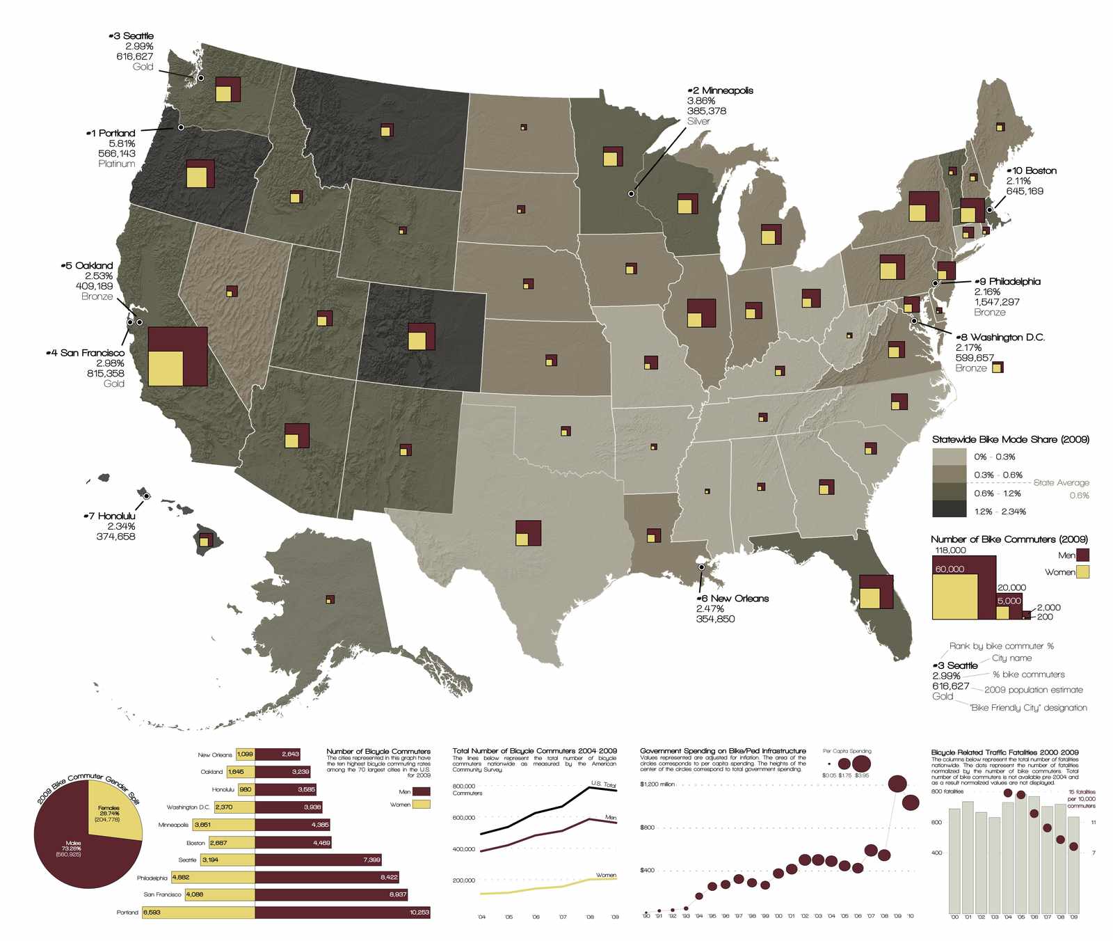
You are almost certainly going to need to enlarge that picture for the full effect, and can do so by clicking on this link.

This map was created by Kory Northrop, a U of O masters candidate in Environmental Studies, and tracks trends in commuter cycling over the last 10 years or so. If you commute by bike, this might not tell you anything new. Yes, theres a shit ton of commuter cyclists in San Francisco - you ride with them in a pack of 40 to and from work every day. Yes, commuter cycling (and the cycling community in general) is male-dominated - nothing new there.

The most interesting part of this study is in the correlation between the rise in government spending on bike/pedestrian infastructure, and the overall decline in bike related fatalities. It would seem as though the government is effectively putting their money to good use in looking out for the interest and safety of urban cyclists, which is pretty rad. Also, there's safety in numbers. As the number of urban cyclists as increased, fatalities have decreased. While you may not like riding around in a pack of old dudes on cruisers who seemingly get joy out of affixing every possible blinking object to themselves/their bikes, at least it's a little safer that way.

Visualizing Mental Maps of San Francisco

Neighborhoodr clued me in to this awesome new set of San Francisco maps today. Started by a couple of Berkeley students, Visualizing Mental Maps attempts to map how San Franciscans feel about their neighborhoods & the city, and the results are really interesting. From the site: 

 
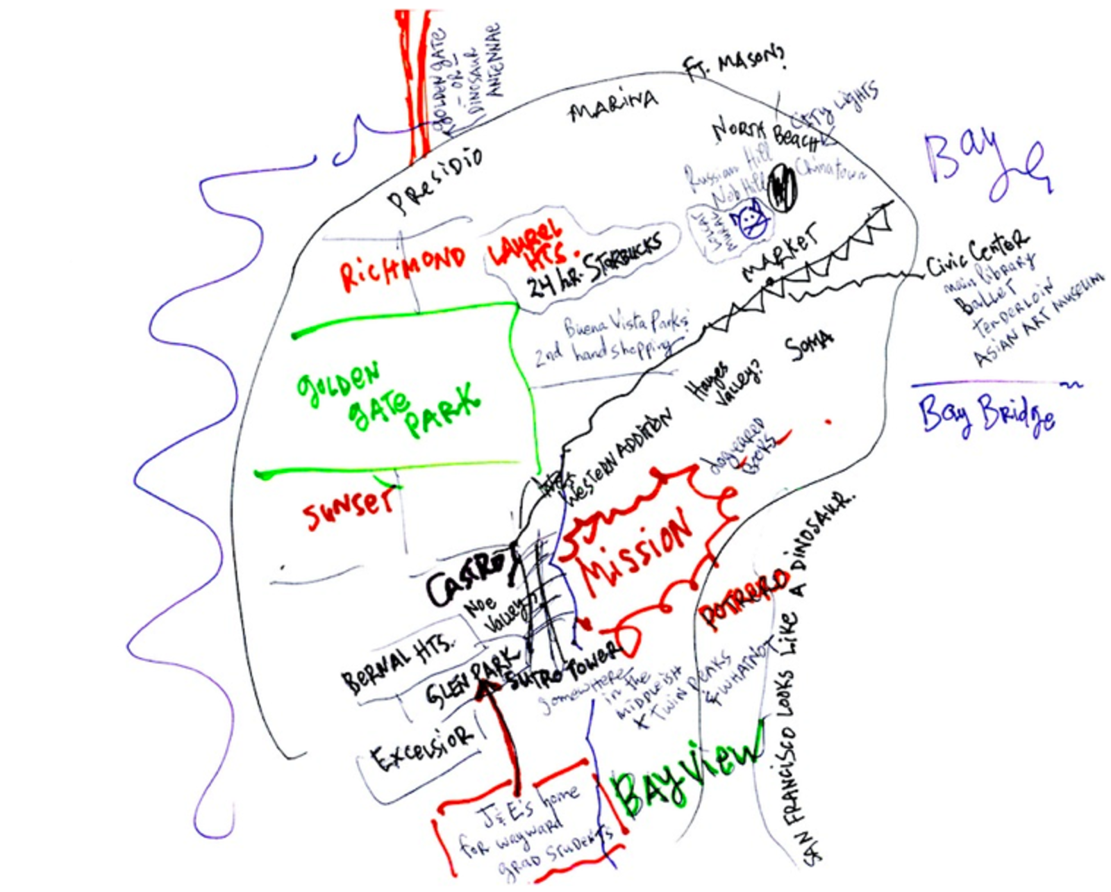
The Visualizing Mental Maps of San Francisco project taps into San Francisco residents' perceptions of the city and its neighborhoods, which aren't always reflected in the geography of a street map. The first part of the project was a qualitative investigation in which we interviewed residents and asked them to draw pictures of their internal images or “mental maps” of the neighborhoods they lived in and of San Francisco. The second part was the creation of visualizations informed by the qualitative research, resulting in this atlas of mental maps.
 
One of my favorite parts of their project is Storymaps, where you can hover above a map of SF neighborhoods and see how the study participants characterize them. 
 
I like the one participant who says about the Marina, “Y'know, its not really necessary. I don't really need this.”
 
The map of hills and pedestrian barriers is also a cool reminder of how San Francisco's unique topography dictates neighborhood boundaries and how we move about the city on foot/bike. I've frequently argued that San Francisco really isn't all that hilly, but I think the only reason I feel that way is because I've become so adept at avoiding the hills, especially when biking. When I lived on Fulton & Stanyan, I'd regularly ride a mile out of my way to avoid that steep two block hill on Stanyan between Fell and Fulton. Because I'm lazy. 
 
 
I just wanted to share this, but you should definitely have a look for yourself because there's waaay more interesting data and pictures on their site than I could possibly hope to unpack in a single blog post. These students really did an amazing job of mapping the spirit of the city in a way that traditional cartography never could. And don't forget to check out the Gallery, featuring drawings of SF maps and neighborhoods from study participants. This one looks like a dinosaur!
 

WHERE'S THE PINBALL AT?

While we're on the topic of maps, I'd like to take this chance to remind everyone about this necessary Google Map project some dude named Timothy is running.  He's out there mapping all the pinball machines in SF the eastern half of SF, which is a crucial set of data for assholes like me with washer and dryer in-unit and an excess of quarters.  All the bars are fairly up-to-date with reviews of the machine's condition and cost breakdowns.

Check it.

HEY INTERNETS YOU LIKE MAPS RIGHT?

if you want to peep the pdf click the image above and you can look at color coded squares explaing how they plan to build more blocks of boring to fill the streets of Mission Bay so that you can live in a fortress of beige without having to see the people who still walk on the street in a neighborhood where the most interesting building is this parking garage. The park at block P6 was finally opened last month after being wrapped off with chainlink fence for fucking months, I guess the lawn was real fancy or some bullshit. 

Mission Loc@l Profiles Eric Fischer

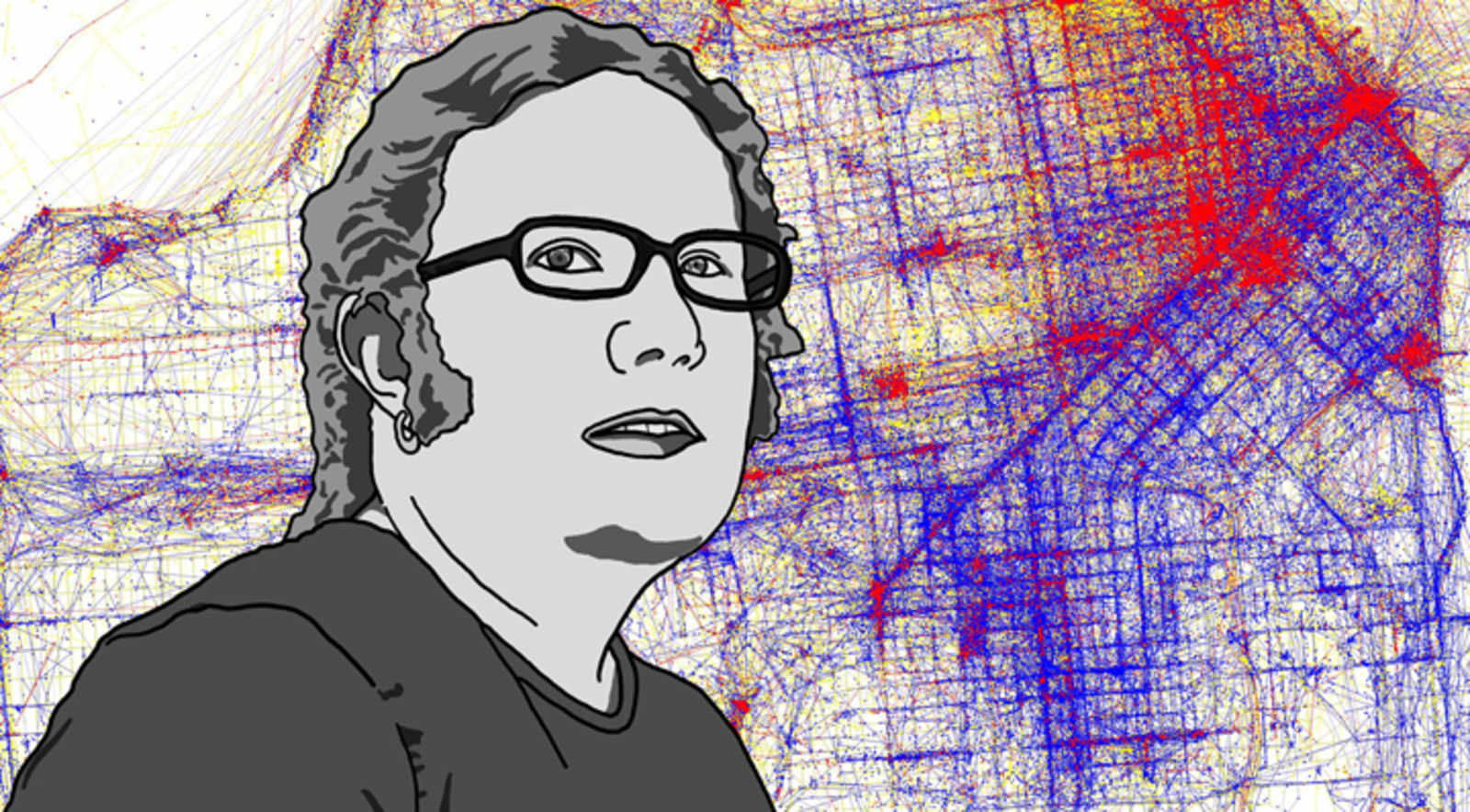
If you've read any of the various SF blogs over the past few years, there's a good chance you've come across Eric Fischer's work.  His flickr account is full of ancient maps, rad data visualizations, scanned photographs from years past, and photos of misspelled street markings.  Despite the massive amount of content he posts, we generally don't get to hear much about the work from his voice.  Lucky for us, Mission Loc@l got an interview with him:

…he’s spent his adult life trying to make sense of urban geography. “This has been a long obsession of trying to figure out what makes some places work and some places not.”

What works? San Francisco, he says. “It’s one of the few places where for the most part it’s easier to walk places than to drive.” And what doesn’t work? “Des Moines, where you’ve got pedestrian bridges everywhere between buildings so that nobody ever actually goes outside.”

And then there’s the great paradox: “Why does the Las Vegas strip work in spite of itself?” he wonders, citing the large numbers of pedestrians in spite of its inhospitable streetscapes. Could it have anything to do with public drinking? “Maybe,” he shrugs.

Read on.

WELL THAT WOULD HAVE BEEN FUN

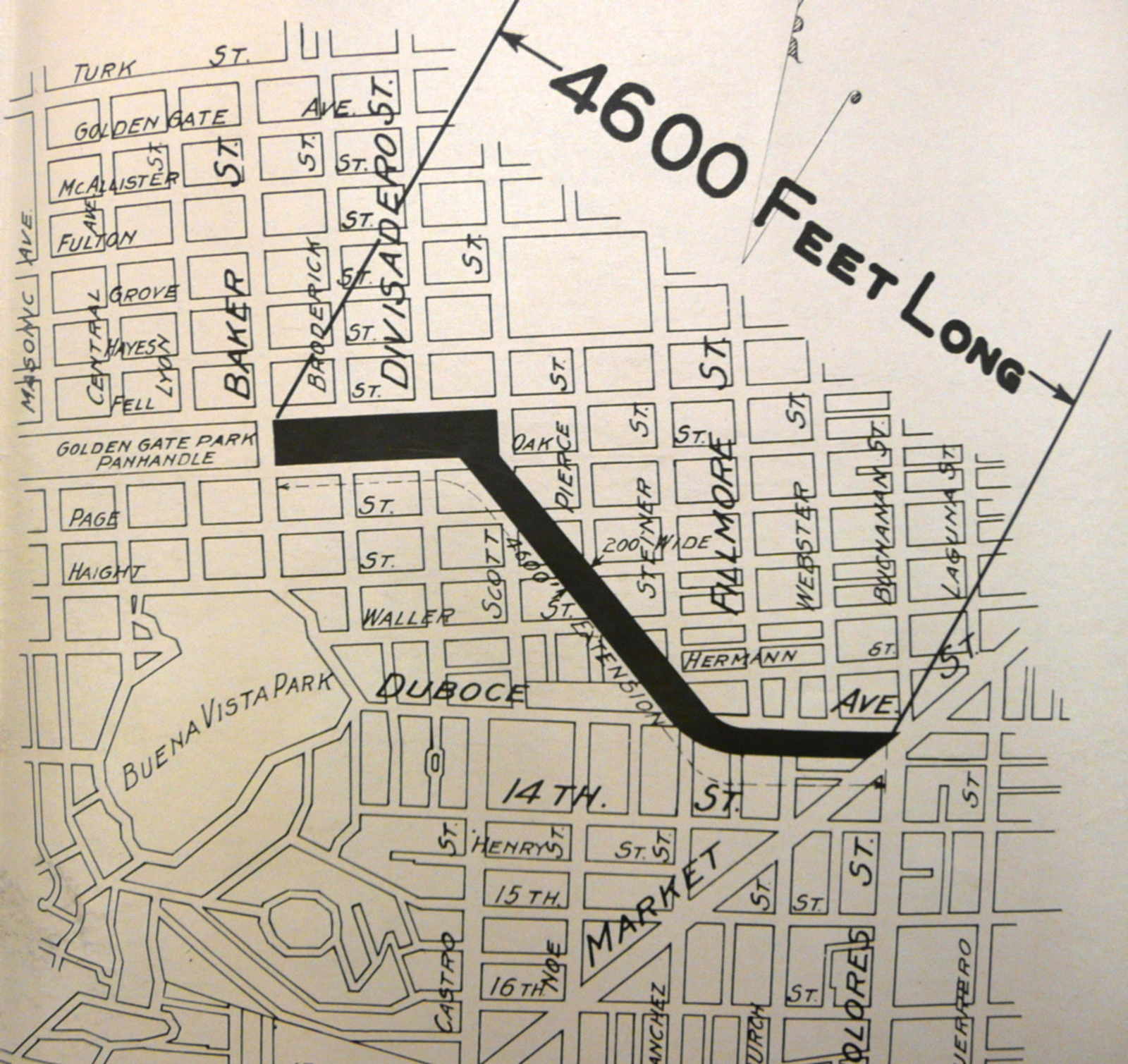
Imagine this: a grassy bike ride all the way to work*, the neighborhood name NOPA doesn't exist and SFPD wouldn't be able to ticket cyclists at the ARCO station.  Well, apparently back in distant year of 1928, the city could have made this a reality.  The plan was to extend the panhandle all the way to Market st. along The Wiggle.  The plan called for demolishing housing along the route, indicating our politicians of years past actually had a spine.

I have no idea why it never happened, but I bet that Great Depression thing had something to do with it.

(via Wikipedia)

* a grassy bike ride to work for people who actually live in the western part of the city… and work.

The Mission for Yuppies

An anonymous reader sent us this map:

Check out the map a yuppie friend drew to explain the Mission to out-of-towners. He characterized my street as “less scary”. Fuck that shit.

We agree.  FUCK THAT SHIT.  We made your friend a better map for yuppies:

There, that's everything white out-of-towners need to know.  Tell your friend he can mail his check for $75 to 300 Beale St., Suite #100, SF 94105

The Mississippi River Flows into the San Francisco Bay

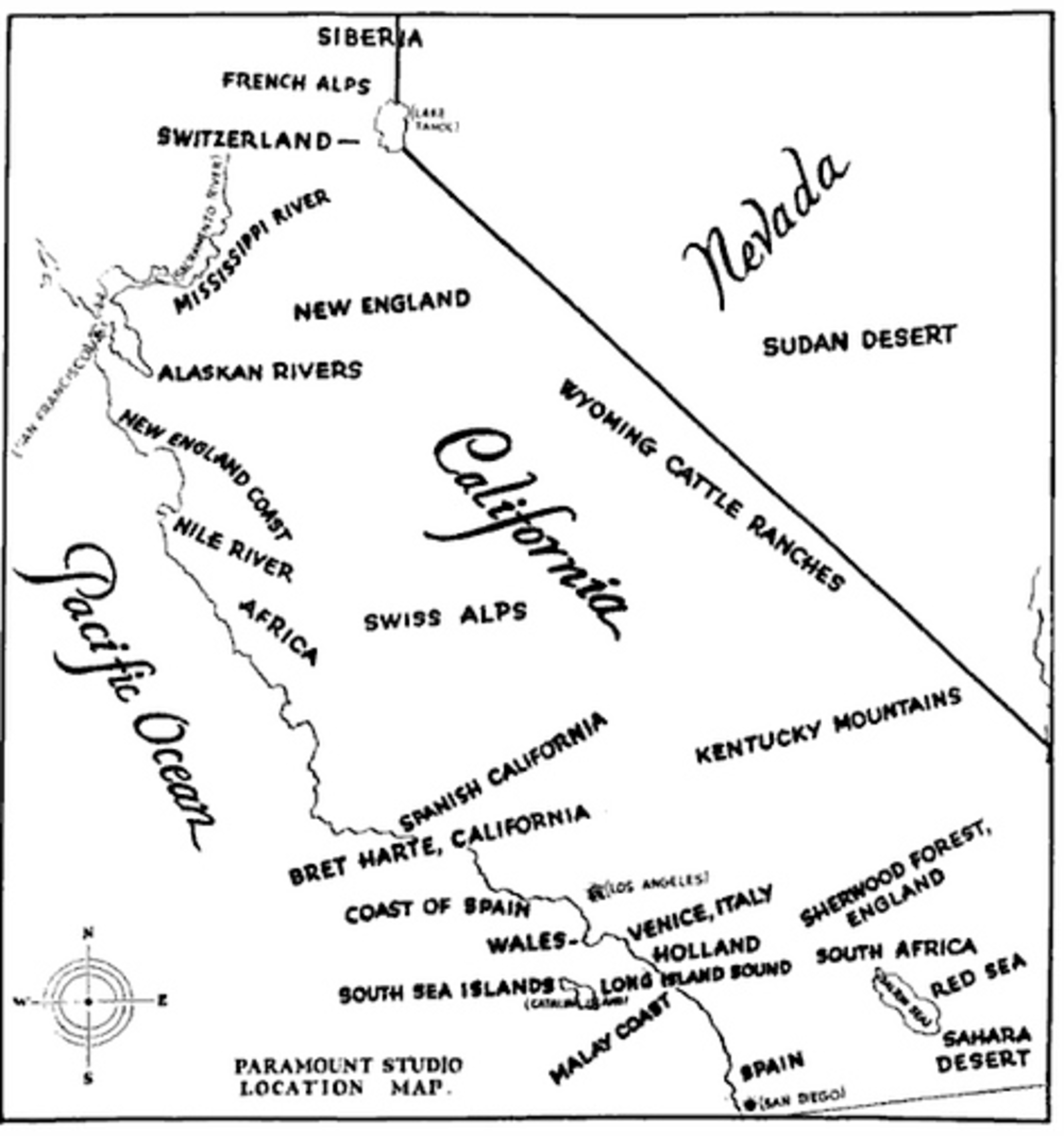
Check out this bad boy: a 1927 map made by Paramount Studios to tell financiers all the locations they could shoot films in “foreign” settings right here in California.  Cool but I hate to tell you, Paramount Studios of the past, that the New England coast doesn’t have redwoods.  Also, were financiers really knocking at your door demanding to know where you could film scenes featuring “Wyoming cattle ranches?”

(link.  Thanks Neil!)

ANOTHER NOVELTY MAP I LIKE

Generic points out this “Handy Map of San Francisco Bay” made way back in a 1938 Cartoon Guide to California posted on Strange Maps back in 2008.  I want this book so I can spill beer and pizza sauce all over while reading it while in the bathroom.  Also, my map would have hella fog, unicorns running around the peninsula while drinking Red Bull and throwing money out of convertibles and mad sea creatures in the ocean.

Pages