— By Josh Constine |
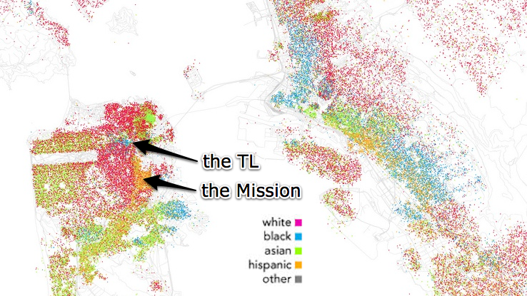
This is a racial breakdown of San Francisco and Oakland based on the 2000 census. I'ma guess the Mission isn't so orange anymore.
Also, considering a move to Portland? You are caucasian.
(map by Eric Fischer)
— By Josh Constine |
This is a racial breakdown of San Francisco and Oakland based on the 2000 census. I'ma guess the Mission isn't so orange anymore.
Comments (9)
Right Josh. Because you and all your friends moved in. But welcome! The Mission welcomes all.
Are you sure that’s the TL? Looks closer to the Fillmore to me
yes the Fillmore not the TL. Know your local history, the Fillmore was the center of black culture in SF until urban renewal bulldozed most of it.
If you look closely at the map, you’ll see a small empty spot to the southwest of the blue section. That is Alamo Square Park, at the southeast side of the Fillmore District (not the bigger spot further southwest which is Buena Vista Park). To the northeast, right where the arrow is pointing, is the Tenderloin. Yes, the blue does permeate the north side of the Fillmore, but that’s not what I labeled as the TL.
Yes, and before that, it was Irish and Italian whites. Not that I care for the rising rents and general homogenization of the city’s population that comes with gentrification, but I think it’s good to look back farther into the region’s history than just the last five or six decades.
Animated census maps from the birth of Christ to 2010! That’d be sick!
“Yes, and before that, it was Irish and Italian whites.” —— Whew! Wouldn’t want any ‘o them Eyetalian colureds invadin’.
If you enlarge the map, you’ll see that (like others have pointed out) the blue area is the Fillmore/Western Addition while the Tenderloin has a variety of colors. Or at least it had them in 2000.
http://thetenderblog.com/2010/09/21/whats-the-most-racially-diverse-area…
venture east of Valencia Valley and you will see humans of Hispanic descent.